
Walk a New Haven Street by Address
Start with the number and street spelling, not a guessed person. In New Haven, the address is a situs key, meaning the location where the parcel sits. Vision can return the owner and parcel card, while the city GIS viewer places that lot among its neighbors. The deed index then adds the legal description and earlier parties. A voter route and a reverse directory add different kinds of resident evidence. None of these layers is a complete list of everyone at a property, so the useful result is a dated chain of records that agree on the same street, lot, and legal description.
Walk the address in a fixed order and keep the source date beside every result. A parcel card can point to an owner, but the mailing address may be elsewhere. A voter entry can show a registered elector, but protected records are suppressed and many people are not registered. A directory line can identify a listed occupant or business from its own era. Keeping those meanings separate produces a practical New Haven street directory trail.
- Enter the street number and name in the Vision New Haven property database. Save the parcel or account key, owner or co-owner name, situs location, and mailing address when the card displays them.
- Open the New Haven GIS Gallery and use the property viewer to place the lot on the street. Record the parcel shape, dimensions, cross streets, and adjacent polygons without treating the map as a deed or survey.
- Take the current owner name to the New Haven SearchIQS land-record index. Search as grantee first, then compare the legal description, book and page, document date, and prior references.
- Use the Connecticut voter lookup and the local registrar route for registered-elector information. Treat the result as a limited public record, not a street-wide list of every person at each parcel.
- For an older street scene, consult New Haven Free Public Library reverse or address sections. Pair the listed name with the street number, directory year, map context, and deed evidence before calling it a past household.
New Haven Address Records by Street
A New Haven street directory is a set of address-keyed records, not one master roll. The assessor and tax search work from property location. The city geographic information system (GIS) supplies shape and adjacency. SearchIQS ties parties to land instruments, while permits, voter files, and reverse directories add narrower clues about use or people connected with an address. The keeper and access route matter as much as the street name.
| Address source | Keeper | Street key | What the record can show | Access |
|---|---|---|---|---|
| Grand List / parcel card | New Haven Assessor | Situs street and parcel/account | Owner or co-owner, mailing versus situs, values, exemptions, physical or sale fields when populated | Vision and GIS; office fallback |
| GIS parcel and dimensions | New Haven City GIS | Mapped polygon, frontage, lot geometry | Parcel shape, dimensions, adjacent lots, streets, and map layers | Public ArcGIS gallery and viewer |
| Deed and map index | City Clerk / SearchIQS | Grantor, grantee, legal description, map or street index | Parties, document type, recording date, book/page or document number, image and legal description | Guest index; images, counter, and copies vary |
| Tax search | New Haven Tax Collector | Name, property location, or bill number | Owner or account trail, tax year, bill number, and payment status | Online search, in-person, and mail routes |
| Permits and certificates | New Haven Building Inspection / CitySquared | Address or property | Applicant, owner, contractor, work date, or certificate fields when a public result displays them | Dynamic portal, office terminal, or Freedom of Information Act request |
| Voter registry | New Haven Registrar / Secretary of the State | Residence address, ZIP, district | Registered name, party, status, birth year, and election history subject to law | Lookup, registrar, or restricted file request |
| Reverse directory | New Haven Free Public Library | Street number and street name | Listed person, spouse or initial, occupation, or business in the directory’s era | Reference room and local-history service |
| Obituary or probate endpoint | Library, Superior Court, Probate | Name, address, and date | Death notice, relative, estate, heir, or representative clue where public | Microfilm, court index, or probate access rules |
The cleanest chain is address to parcel, parcel to owner, owner to deed, and deed to an earlier legal description. Tax and permit records can confirm that the address was active in a given period. Directory and voter records answer different person questions, so a matching street number is useful evidence but never a guarantee of residence or title.
Search a New Haven Street in Vision
The Vision New Haven Online Database is the first stop for an owner, address, or parcel trail. Its welcome screen exposes an “Enter Online Database” control, and the city directs property research to the assessor database. The portal notice identifies 2021 as the state-mandated revaluation year, uses October 1, 2021 fair market values, and notes that earlier assessments used October 1, 2016. Values are reference information, not a legal description or conveyance.
The inner form loads dynamically. Research confirmed the owner-name, property or situs address, parcel or account, and ZIP-capable modes, but not the exact labels, partial-match rules, result cap, sort, export, or whole-street browse controls. The field map separates confirmed functions from details that still need a live browser check.
The official Connecticut parcel and computer-assisted mass appraisal (CAMA) schema is useful as a field reference for a New Haven card, not as proof that every Vision result exposes every statewide field.
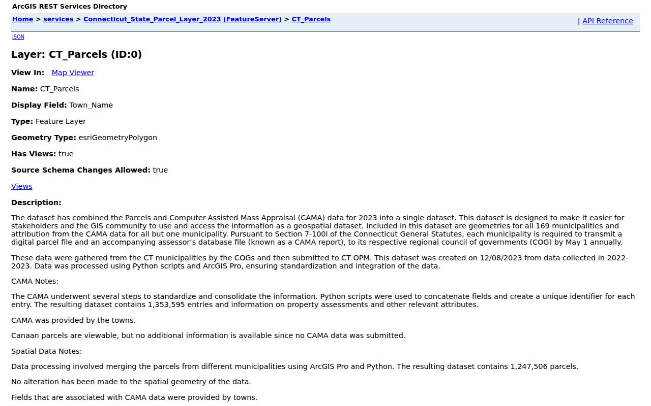
The schema groups identity, valuation, physical use, sale, and maintenance fields. A New Haven card may leave fields blank, and a mailing address can differ from the situs location, so record the assessment date with the owner result.
| Field or control | Type | Required | What New Haven research confirms |
|---|---|---|---|
| Owner or name | Text / search mode | Not exposed | Owner-name lookup is supported; partial-match behavior was not captured. |
| Property or situs address | Text / address mode | Not exposed | Address lookup is supported; separate number and street fields were not exposed. |
| Parcel or account number | Text / search mode | Not exposed | Parcel or account lookup is supported; the local format was not located. |
| ZIP filter | Filter / search mode | Not exposed | A ZIP-capable screen exists in the capture plan; return behavior and counts remain unconfirmed. |
| Mailing address | Result field | Not exposed on landing | May differ from the situs and does not establish who lives at the parcel. |
| Value, sale, and physical fields | Result fields | Not exposed | Use only labels shown on the live card; the statewide schema is a planning inventory. |
| Sort, print, export, and paging | Controls | Not exposed | Result count, pagination, export, and whole-street browsing were not confirmed. |
Read New Haven GIS Along the Block
The map step keeps one street from being confused with a nearby lot that has a similar number or a different mailing address. Open the city’s property-information viewer, zoom to the street, turn on parcel or dimension layers, and click the target polygon. Save the popup, parcel link, legal location, and cross streets if the viewer exposes them. Then pan and click the lots beside and across from the target.
New Haven’s parcel-dimension layer is a cached citywide map service. The viewer supplies map, zoom, layer, legend, and identify context, but the unattended capture did not expose exact popup fields, selection tools, buffer or radius controls, measurement behavior, or export. The map is therefore a way to order the street record, not a substitute for the deed or a survey.
The New Haven ArcGIS property viewer is the map-first place to compare a target lot with its surroundings.

The captured viewer shows the parcel-identification context used for a street walkthrough. A selected polygon still needs a Vision card or deed description before it can anchor a person or ownership trail.
Open New Haven’s GIS Gallery
The New Haven GIS Gallery is the city entry point to public mapping applications. It helps locate the correct property app before a searcher tries to compare lots, street segments, or neighborhood context. Use it to start with a known street, then move from the map to the assessor card and the land-record index.
A map layer can show dimensions, parcel outlines, streets, and nearby lots. It cannot by itself show a complete household, prove that an owner resides at the situs, or replace a recorded legal description. Keep the map date and the parcel key with the rest of the street directory notes.
The gallery’s public app collection provides the city’s route into GIS rather than a separate person directory.

This capture documents the New Haven map entry point. The property viewer remains the tool for clicking a parcel, while the gallery supplies the broader app and layer context.
New Haven’s City Clerk Land Records
“New Haven County Recorder” is the wrong destination for a current land search. Connecticut counties have been geographic names since county government ended in 1960, with records and elections administered through the towns and cities. New Haven’s City Clerk is the land-record custodian, local registrar, and counter for municipal land records, maps, trade names, local record copies, and recording services. Route deeds and plats to the City Clerk, not to a county office that no longer operates.
The New Haven City Clerk is also the fallback when an older book, certified copy, or image question cannot be answered in the online index. A standard recording schedule lists $70 for the first page and $5 for each additional page. Copies are listed at $1 per page, or $2 for a certified copy. SearchIQS image charges are separate from the counter’s copy schedule.
The tax route is city-level as well. The New Haven Tax Collector search accepts a name, property location, or bill number. Current access includes online search, in-person service at 165 Church Street, and mail to the city’s listed post-office box. The office phone is 203-946-8054. A tax bill or payment status can tie an address to an account and year, but it is not a complete list of residents.
Search New Haven’s Street Index in SearchIQS
SearchIQS gives New Haven’s street directory work a second entry point beside owner-name searching. The help page identifies a “Map Index by Street” along with grantor and grantee modes. That street-first route is useful when a historic address has no modern owner name, when a subdivision changed the parcel, or when a legal description is easier to recognize than a person. The current help page, updated May 30, 2024, lists New Haven land records with index and images from July 26, 1951 to the present. Maps reach from January 1, 1835 to the present. An older City Clerk or SearchIQS PDF gives August 18, 1952 as the land-record cutoff and distinguishes older map-image periods. Treat the current help page as the better current citation, while retaining the older date as a source conflict when a search sits near the boundary.
Guest index searching is the no-login route. Images may require an account, subscription, or a $2 download or print charge under the unlimited plan. When a chain reaches beyond the online run, ask the City Clerk about older volumes, certified copies, and image questions. Do not assume the unattended page exposed every inner search field, document-type option, date control, result cap, or sort order.
A useful SearchIQS result inventory includes:
- Grantor and grantee names, with the party role that sets the direction of the chain.
- Document type, such as a deed, mortgage, release, lien, quitclaim, or map when the index exposes it.
- Recording date and the book, page, or document number used to cite the instrument.
- Legal description, including lot, block, bounds, or a related map reference when present in the image.
- Image access status, with guest index access separated from account, subscription, or download access.
- Redactions or protected fields that should not be copied into a personal research note.
Note: Record the coverage source and access date beside each result, because New Haven land-record cutoffs differ between current help text and an older clerk PDF.
New Haven’s Grid and Old Addresses
New Haven’s original street pattern makes intersection clues unusually useful. Yale’s description of the Green and Nine Square Plan places the Green at the center of a half-mile nine-square grid, with George, York, Grove, and State as historic references. Ninth Square sits southeast of the Green. The 1748 Wadsworth Plan adds early creek and canal context. These maps explain why older street research often works best by grid, intersection, and nearby landmark rather than by a modern mailing label.
New Haven was established in 1638, named in 1640, incorporated in 1784, and consolidated as town and city in November 1895. A record can therefore use a city, town, county, ward, square, or neighborhood term without changing the underlying parcel. Current names such as Wooster Square, Fair Haven, Westville, East Rock, West River, the Hill, and the Annex are helpful context, but they are not deed boundaries.
No verified official year for New Haven street renumbering was located. When an old number does not line up with a current card, bridge it with intersections, the SearchIQS street index, the legal bounds, Sanborn sheets, adjacent streets, and the parcel’s prior book and page. A ward or zoning map can guide the search, but it is not an address database.
Trace New Haven Street Deeds
Deeds are party-keyed instruments, not a ready-made street roster. Once Vision or GIS supplies a current owner and parcel, search that owner as grantee in SearchIQS. A grantor is the party transferring an interest, while a grantee is the party receiving it. Record the grantor, grantee, document type, recording date, consideration if shown, book and page, legal description, lot or block, and map references. Then search the grantor backward only when the legal description still matches the parcel.
The legal description is the safeguard against a false chain. A street number can change after subdivision or renumbering, and a same-name party can own a different lot. Compare the deed’s bounds or lot and block with the map, then compare the next prior instrument. For older records, the City Clerk counter, library microfilm, state-held material, and a written records request are the fallback chain. SearchIQS maps reach farther back than the current land-record index, so a map reference may bridge a historic address to a legal lot.
Address terms.
- Parcel
- A mapped unit of land tied to an assessor or account record. It is not a list of every person at the site.
- Situs address
- The street location where the parcel sits. It can differ from the owner’s mailing address.
- Plat
- A recorded map that helps show lots, streets, subdivisions, and legal relationships.
- Criss-cross directory
- An address-to-person or business reference, with New Haven reverse sections reaching back about the 1920s.
A current parcel value is not the same thing as a historical sale date. New Haven’s 2021 and 2026 revaluation timing can make an assessor figure look newer than the deed event being traced. Keep assessment dates, recording dates, and map dates in separate columns.
Check New Haven Permits by Address
Permits and certificates add a work chronology to the street record. The New Haven CitySquared/Municity portal is the current electronic application route, and the city also provides office terminals. A public result may show an address, work date, applicant, owner, contractor, or certificate detail, but the exact result fields were not exposed in the research capture. Older permits or certificates may remain offline.
Use the address and parcel key from the assessor or GIS card before looking for a permit. If CitySquared does not answer the historic question, the city’s Connecticut Freedom of Information Act (FOIA) records-request route is the documented fallback. The city says written or oral requests are accepted and encourages a written request. Exemptions, redactions, statutory fees, and safety limits still apply, so a request should name the address, record type, and date range without asking for a person list.
The CitySquared capture shows the current permit portal entry point.
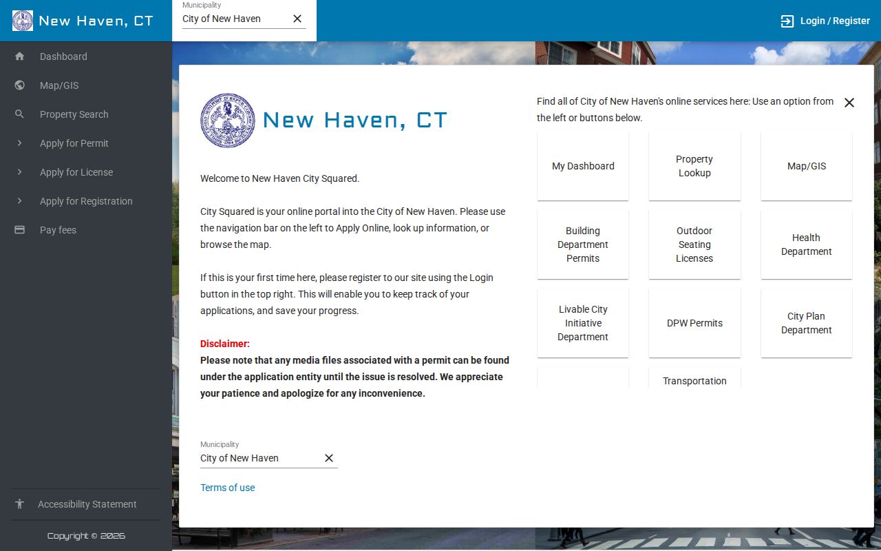
The portal is useful for current address-keyed applications, while older or hidden items may require the office or FOIA route. A permit identifies a documented project, not every person connected with the address.
New Haven Street Voter Records
Connecticut’s local registrars maintain the official voter list, and the Connecticut voter lookup is the public starting point for a name or polling-related check. Research for the street route identifies residence address, district, party, status, birth year, and participation as possible voter-file fields. Full date of birth, license or Social Security identifiers, protected addresses, and ballot choice are not public.
A street-wide request is different from the web lookup. The state’s voter-file route describes a 2026 public file priced at $300, delivered as comma-separated values (CSV), and tied to a permitted-purpose certification. A file request is not a promise that every person at a parcel appears in it. Address Confidentiality Program participants and other protected voters are suppressed, and inactive or unregistered people will not create a public voter entry.
The state voter privacy and file guidance explains the limits. For a narrow address question, start with the official lookup or the New Haven Registrar of Voters rather than treating a full file as a household roster.
Note: A public voter file is a separate request, not proof that every person at a New Haven address appears in the registry.
Read New Haven Streets in Reverse Directories
New Haven Free Public Library holdings supply the historical street layer. The library reports city directories from 1840 through about 1990, complete microform coverage from 1840 through 1960, and reverse or address material reaching back about the 1920s. Most later volumes were produced by Price & Lee. An address section can list a household head, a spouse or initial, an occupation, or a business, but it is not a full census and does not prove ownership.
Use the NHFPL city-directory research guide to choose a year and locate the reverse section. The Local History Room adds newspapers, microfilm, maps, research guides, FamilySearch affiliate access, and an obituary search service. The historical collection itself belongs to the New Haven city directory reference route, while this street directory uses it only to test who was listed at a particular number in a particular era.
Check the street alphabet, number, ward or neighborhood term, publisher, and year together. If optical character recognition (OCR) changes a surname or street, inspect the scan. Then compare the address line with a deed, map, obituary, or later directory. A person appearing in a reverse section may have been an occupant, a business contact, or a household-head entry, so the language of the record matters.
Compare New Haven ZIP and Situs Layers
A ZIP is a routing label, while a situs address is the parcel location used by local records. The United States Postal Service (USPS) ZIP Code Lookup offers address, city and state, and cities-by-ZIP modes. In address mode, street address and city are required, the state is selected, and an apartment or suite can narrow a result. USPS warns that a ZIP result does not confirm a person or company and does not guarantee a business location.
New Haven research uses USPS references and Census ZIP Code Tabulation Areas (ZCTAs) differently. ZCTAs 06510, 06511, 06512, 06513, 06514, 06515, 06517, and 06519 intersect the city, while other New Haven mailing labels can include PO-box, institution, or adjacent-town context. ZIPs such as 06512, 06513, 06514, 06515, 06517, 06524, and 06525 need a municipality check before a parcel is treated as a New Haven record.
Vision appears to be the local ZIP-capable property screen, but the ZIP field, return behavior, ZIP-wide count, and export were not confirmed. Tax accepts property location, while GIS, voter lookup, and CitySquared ZIP behavior were not established. Use the street and situs fields to settle the parcel question after ZIP routing has narrowed the search.
Note: USPS routing data can point toward a place, but the situs parcel and municipality control local property research.
Limits of a New Haven Street Directory
A street directory can identify a parcel, a titled owner, a recorded party, a permit applicant, a registered elector, or a historical listing. It cannot turn those separate records into a guaranteed list of current residents. Assessor and GIS results focus on parcels and titled owners. Voter records identify registered electors. A reverse directory may show only a household head or business. DMV address data is closed under federal DPPA rules that restrict personal information from motor-vehicle records, and utility or delivery customer lists were not located as public datasets.
Protected residents can be hidden by Connecticut’s Address Confidentiality Program, the voter privacy program, or another statutory nondisclosure rule. A parcel line is not a social boundary, and a mailing address is not proof that the owner lives at the situs. When records conflict, preserve the dates and ask the custodian about the exact instrument or card rather than filling the gap with a guess.
Lawful personal use. New Haven street and address records are suitable for lawful personal research, family history, property history, and civic inquiry. Do not use a record to stalk, harass, intimidate, or harm anyone, and respect protected-address rules.